|
Lake Kerkini, called Limni Kerkinitis in my Phillips New World Atlas (Limni being the Greek word for lake) lies just south of the modern Bulgarian border with Greece on the river Strymon or Strimon or Strymonas. Many names are still variable in Greece, a hangover from the changing governments and attitudes that have been in power throughout the twentieth century. You can find the names of towns spelled differently on different maps, and yet differently again on roads signs, you get used to this as you fall in love with the country and its lack of rush and hustle.
The river Strymon originates high on the slopes of Mount Vitosha in Bulgaria, a few kilometres south of Sofia. It is 410 km long and has a drainage basin of more than 17,000 km2, of which 6,300 km2 lies within Greece, most of the rest is in Bulgaria, though it also draws some water from former Yugoslavia. The lake also receives water from the Kerkini or Kerkinitis River, a small river less than ten metres across and 11 km long which flows into the western most point of the lake.
As well as these two rivers the lake also receives water from a number of small streams that run rapidly out of the southern side of the Serbo-Macedonian massif. This mountain range, which marks the Greek-Bulgarian border, is known as the Beles Mountains to the Bulgarians and Kerkini to the Greeks, however everybody here in Greece refers to the whole range as Beles but I shall refer to it as Kerkini Mountains as this is the officially recognized name. The highest peak is mount Kerkini (2,031 m). The border between the two countries actually runs along the top of the mountain range where it is delineated by a series of small cairns and a ditch about ten centimetres deep and forty five centimetres wide. You can, if you like, walk along with one foot in each country.
The southern side of the Kerkini Mountains border the northern side of the lake, there is a strip of land 1 to 2 km wide from the lake edge to the real base of the mountains across which the land rises gently enough to be farmed. Crops are grown nearer the lake and livestock farmed nearer the mountains, although cattle are pastured all over the mountains during the warmer months, particularly above the treeline where grass is more abundant.
To the southwest another small mountain range, known as the Mavrovouni (Black Mountain), with Mount Mavrovouni (1,179 m) as its highest point, makes another natural boundary to the lake. These mountains are also often referred to as the Krousia Mountains locally, the Bulgarian name for them, however I will use the term Mavrovouni from now on. The land to the east and west is pretty flat, and there are dykes on both these sides of the lake. While the mountains are the result of uplift the plain of Serres was partly created by subduction along several fault-lines. The mountains themsleves are both composed of metamorphic rocks and contain a lot of gnieses and schists, quartze is very evident higher up on Kerkini and the rocks of Mavrovouni break down to make a very silicaceous sand.
The lake is roughly 4 sided but the Eastern and Southern sides are much longer than the other two and inwardly curved giving it an odd pointed shape. Perspective is an important consideration however and from the top of the Kerkini Mountains the lake actually looks like a rather fat letter X, something which surprised me when I first saw it. The end of the long thin corner points southeast towards the Aegean Sea and ends at the village of Lithotopos, where the river is dammed.
The dykes, or embankments, are both accessible to cars and there is a tarred road from the village of Kerkini to the village of Lithotopos that runs adjacent to the lake edge for much of its route, and is never far from the lake. The river is also constrained within embankments that can be driven along.
This leaves three sides of the lake easily accessible to tourists and enhances the bird watching of the lake. Although there are tracks suitable for tractors and four wheel drive vehicles along the northern edge of the lake these are pretty rough and generally flooded during the spring, and summer. There is a small harbour on the north side of the lake at Mandraki that gives some access to the northern side of the lake. There is also a harbour with a cafe on the western edge of the lake near the village of Kerkini and another at the southern tip of the lake at Lithotopos.
The lake changes its size drastically throughout the year, water is trapped during the late winter, spring and early summer rains and because of the gentle slopes, found around much of the lakes edge, the rising water greatly increases it size. It reaches its maximum volume in early to mid summer and then through late summer it shrinks again as the water is let out to facilitate the watering of crops on the plain of Serres further south.
The high and low water marks for the lake, across an average year, differ by 4.5 to 5.0 metres, which is a considerable variation in water depth. This causes many problems for the local fauna and flora. The surface area of the lake changes from 51.5 km2 to 74.4 km2 during the year, while the volume of water in the lake varies from 90 to 411 million cubic metres of water. The lake has a pH value of about 9 at its surface and around 7.5 in its depths and is semi-eutrophic, meaning it would be eutrophic if it had a smaller turn over of water. It is estimated that the total volume of water passing through the lake is around 13 times its average contents.
The lake is a man made lake, and, in its present form it has only existed since 1982 when a new dam was built at Lithotopos, at this time the eastern dyke was raised and the western one created. To understand both the beauty and the tragedy of the lake we need to look a little more deeply at its history.
Two hundred and fifty million years ago the whole of Greece was a flat area, part of the bed of the Sea of Tethys. The land was uplifted twenty-four million years ago as the orogenic activity that gave the Balkans their delightfully mountainous appearance occurred. There followed many more years of changes and development and among the few fossils from the area are those of an anthropoid ape, Graecopithicus sp. a distant cousin that lived here 8 or 9 million years ago and later, a mere 350,000 years ago, we find the remains of closer cousin, a member of the genus Homo, probably H. erectus.
Humanity as we know it probably settled in the area about 30,000 years ago, however settlements probably did not occur before 6,000 or 7,000 years ago. The landscape then was still very different from what it is now. With the end of the ice ages, 10,500 years ago began the melting of the glaciation in the Pirin and Rodopi mountains in southern Bulgaria.
Much of this water naturally ran south, rushing its way through a narrow passage that existed between the Serbo-Macedonian Massif and the Rila-Rodopi Massif. This passage, which we now call the Ruppell's gorge, was later to become a major inland roadway for the seafaring ancestors of the Thracians who arrived in the area about 2,000 years before Christ driving out the Barbarians who were here before them.
The river, having found its way through the mountains flowed out past the eastern edge of the Mavrovouni mountains in a mad rush of stored energy and spread across the plain of Serres where it formed an inland delta 180 km2 and huge a lake before flowing more gently into the Aegean Sea. Over thousands of years the river brought its clastic materials from the mountains further north and deposited them here, courser material dropped out of the water first, then, as it slowed, finer sediments were also deposited.
The huge glacial lake was shallow and rich in nutrients, vegetation grew and died adding the carbon it had garnered from the air to the rich soil already forming and helping to fill the lake further. The flooding must have been regular and extensive, and in the process large fertile flood plains were created. Eventually these alluvial deposits filled in nearly all the lake. The pattern of water flow changed on many occasions, channels were cut, filled and abandoned, throughout all this time the area remained a huge wetland, rich in both plant and animal life.
By the time mankind started keeping records, and up until the 1920s, there were two lakes in the plain of Serres. A small one where lake Kerkini is now and a larger shallow one further south nearer Serres. The smaller more northerly lake was called Prassias and the more southerly one Kerkinitis. The smaller one would dry out in hot summers. Between them they created a water surface area of 85 km2 and a supporting marshland, mostly reed beds, of 114 km2. This represented a huge resource for wildlife, mostly Amphibians, Birds, Fish and Insects, but also for Reptiles, Mammals and other invertebrates.
About 1,900 BC a group of Thracians from Limnos called the Sintous or Sintious moved into the area, these were the first people we can seriously call Greek who lived here. They built towns, most of which are long since gone, but some, such as Skotousa and Iraklia still remain. Iraklia for instance was built by a king to commemorate his victory over the barbarians in a huge battle fought at the foot of the Kerkini Mountains. These people had a relatively small effect on the landscape and for the most part lived in harmony with nature, the Peones for instance lived in huts built over the open water of the lake Prassias.
They had no shortage of food while they existed in relatively small numbers as hunter gathers. A coin of the Visaltes, an ancient Thracian tribe that inhabited the area depicts a common crane and wild geese were a common emblem of the coinage of the Edonians, another Thracian tribe of the area. However growing crops was a chancy business, although the soil was rich, the river was prone to flooding.
In the 5th century BC the expanding Macedonian empire evicted or subjugated these peoples and the area entered what we think of as Classical Greek History. Herodotus visited the area and wrote of the incredible richness of the area in terms wildlife. Those areas not under water were heavily wooded and it is estimated by some archaeologists that the advancing Persian army used 12,000 logs cut from the surrounding forests to bridge the Strymon at Amphipolis in 480 BC.
We have reports from a few ancient travelers and historians such as Herodotus all of whom stress the abundance of wildlife in the area. According to Herodotus there were Lions, Leopards and Lynx in the mountains as well as huge numbers of fish and fowl. He mentions two types of fish, "Paprakes" and "Tilones", of which he says they were so plentiful that the locals "...gave them for fodder to their horses and beasts of burden"
During the Ottoman occupation of Greece the smaller lake became known as Butkove, and then was later named Kerkini and the more southerly lake became Achinos. Towards the end of this time the Englishman William Leake saw the area, in 1806, and he was amazed at the huge numbers of birds that frequented the marshes.
Mankind is a constructive as well as destructive animal, in fact the two are merely the sides of a single coin and it might be better to call mankind a manipulative animal. The irregular flooding seriously inconvenienced the early inhabitants of the Kerkini area and so the first land transformations were carried out, ditches were dug for drainage and dykes erected to control the wild and unpredictable river that was the source of all the areas riches. Mankind slowly began to impress his patterns and ideas upon the environment.
During the Ottoman occupation one Chatzi-Tachir Bey formed an ambitious plan to drain the Achinos and trap the Strymon between some permanent banks. His plans fell into shadow however with his untimely death and nothing more was done until after the 1st World War when the Greek government commissioned the English engineer S.J. Kenry to devise a plan to 'make good' the area of East Macedonia. Kenry did his job and the Greek government got as far as agreeing to his proposal, but the financial instability of the time scuppered the chances of anything actually being done.
Then disaster struck. In November 1922 Ismet Pasha of Turkey, having defeated the ill-considered war of appropriation launched by the Greeks, announced that all the remaining Greeks and Armenians within Turkey had two weeks to leave. The actual numbers appear to be in dispute but the population of Greece was rapidly increased by somewhere between 500,000 and 1,000,000.
Reading the newspaper reports of the period, in this unsettled time, is scarily deja vu. The faces of the politicians bartering peoples lives for the sake of careers and material rewards have changed as have the editors of the newspapers, and some of the names of the countries are different, but one is led, inevitable, to the conclusion that humanity has not matured in the slightest over the last one hundred years, nor, it appears, have we as a species, learned very much wisdom.
Putting hindsight aside and returning to Kerkini we find that many of these unfortunate refugees were settled on the plain of Serres. In deed, the village where I am writing this book, Himmaros, is mostly populated by people arising from this massive input of humanity and the people I ate my lunch with today all have ancestors who lived in Turkey one hundred years ago. The people in this village came from a part of Northern Turkey along the coast of the Black Sea around Trabzon. Now they call themselves Pondius Greeks and many still use a few words from a language they call Pondiac, which is closer to ancient Greek than is modern Greek.
Between 1922 and 1928 approximately 85,000 refugees came to the area, mostly they were settled in villages such as Himmaros, but some went to the city of Serres. The conditions they settled into were very poor, the river's flooding still made growing crops difficult and malaria, which was endemic in Northern Greece at the time, was happy to reap a dire crop amongst the weakened immigrants. In the year 1923/24 20% of the resettled people in the area died.
Such a horrendous human death rate forced the Greek government to take action and in 1928 they contracted the American firm John Monks-Ulen & Co. to convert the desolate unhygienic area of the plain of Serres into thousands of hectares of fertile arable land.
At the centre of the plan was the construction of an artificial lake on the site of then lake Kerkini to control the river's voluble oscillations, and the subsequent drainage of lake Achinos. The work took several years to complete and necessitated the building of a 7.5 km long embankment to the height of 33m above sea level (a.s.l.) to protect the eastern edge of the new lake. Further to this the river Strymon was redirected and compelled, by embankments, to a follow a stricter course and numerous ditches and canals were created to control and direct the flow of the water throughout the nearby land.
The resultant lake trapped the waters of winter and early summer and released them later in summer with a subsequent change in height from 25m a.s.l to 32m a.s.l., at which point it had a surface area of 85km2.
However Nature was not to be so easily tamed and Mankind's calling the lake a water reservoir did not stop the river dropping tons of alluvial deposits into it every year as it flowed on past. In fact the stillness of the water in the lake increased the levels of deposition. Furthermore subsidence soon threatened the foundations of the dam. Thus, in 1952, the embankment was raised to 34 m a.s.l., and the dam foundations were strengthened, in order to allow the lake to continue to function as a reservoir.
Time passed, the river flowed, and further siltation accrued. Between 1952 and the mid 1970s the lake's holding capacity was reduced by 50%. Meanwhile the area of land under cultivation on the Serres plain had increased from 6,000 hectares in 1950 to 58,000 hectares in 1980. In 1955, 1957, 1962 and 1963 severe flooding struck the plain and it was obvious that the lake as it existed was unable to do the job required of it. Therefore the decision was taken to increase the holding capacity of the dam again.
Thus, in 1982 a new higher dam, with a maximum elevation of 41m a.s.l. was completed, the embankment on the eastern shore was raised again and a new embankment raised on the western shore, both to a height of 39m a.s.l.. This increased capacity meant that the maximum water level in the dam continued to rise. During the 1980s it crept up to 35m a.s.l., in 1990 it reached 35.6m a.s.l. where it remained stable then until 1995 when it jumped to 36.38m a.s.l., the highest level it has so far obtained.
This massive increase in the water's maximum depth had a disastrous effect on the ecology of the lake. Areas of land around 33m a.s.l., that had never been flooded before 1982, were now flooded for five months of the year, sometimes by more than 3m of water. The flooded forest in the northeastern part of the lake that had become the main nesting area for many water birds, after the destruction of the reed beds that had been their prior nesting site, was most seriously affected and hundreds of trees died. Besides this during the actual work much forest was destroyed and the river was again redirected and fully embanked.
Plants, even more than animals, are vulnerable to sudden changes in water levels, especially changes that involve large yearly fluctuations. The lake now experiences a yearly variance in water level of around 5m. This is too great for much the emergent vegetation and huge areas of water lilies have been lost. The mudflats revealed by the winter low water levels are practically devoid of invertebrates in some areas because the land is too deeply inundated for the other half of the year. This greatly reduces their value to the wading birds that used to gather here during the winter.
The changes in water level mean that since 1982 the area of shallow water available during the summer has decreased from 2,400 to 600 ha while that winter shallow water area has increased from 2,100 to 2,800 ha. Ecology is never simple; the immense interrelatedness of cause and effect in the environment of any system makes it very difficult to predict the results stemming from changes in any particular component.
However the world political view during 1970s and 1980s was, as it still is to some extent, that dams and draining wetlands was an excellent thing to do, and the small voices of those ecologists with sufficient sight to see that these wetlands were essentially important to the health of the planet were blown away in the winds of technological dominance and short-term economic imperatives.
All the wildlife of the area was affected by the formation of the lake and the draining of the surrounding wetlands and then further affected, in different ways, by the changes in water levels resulting from the additional works on the dam and the embankments.
While the general opinion is that the overall diversity and complexity of the system has been diminished by each set of changes not all species have been negatively affected by all the changes, and nature is a great healer given time.
Moreover the changes are not all completed, but rather they continue to unfold as the years roll by and the wildlife of the area strives to adapt to, and modifies, each new feature of the environment.
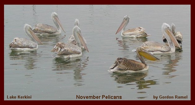
So immense was the richness of the area that even after suffering a great reduction in its carrying capacity, in terms of wildlife, it still remains an incredible place. In 1980 Ben Hallmann described Lake Kerkini as the richest wetland in Greece, in 2004 Dave Gosney descibed it as the premier birding site in all of Greece. Though it may well have fallen into second place behind the Evros delta in ecological terms it is still number one from a tourist, or bird watcher's point of view.
|